Attention !!! The maps shown on this website are for informational purposes only. They are not suitable for navigation. The map provided by the rental company must be strictly adhered to.
Waterways Ireland wishes to advise that the canal is closed at Fowlard’s Bridge , where it meets the N55 north of Ballymahon, with immediate effect until 16th March for essential bridge maintenance works by Longford Co.Co.
Please see below updated information for masters and owners on boat passages in or out of Dublin on the Royal & Grand Canals in 2016. Movements in or out of the city will be organised by prior arrangement to take place as a single movement in one day. Boaters will be facilitated to travel the system if their passage is considered to be safe by Waterways Ireland and they have the valid permit(s) for mooring and passage.
For boat passage through the locks east of Lock 12 into / out from Dublin on either the Royal or Grand Canals, Masters are requested to contact the Waterways Ireland Eastern Regional Office (M-F 9.30am-4.30pm) on tel: ++353-(0)1-868-0148 or email dublincanals@waterwaysireland.org prior to making passage in order to plan the necessary lock-keeping assistance arrangements.
On the Grand Canal a minimum of two days notice prior to planned passage should be given and, with the exception of pre-arranged events, a maximum of 2 boats per day will be taken through the locks, travelling either east or west.
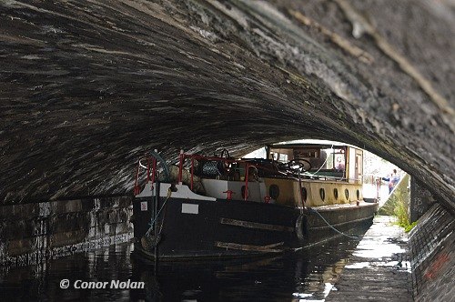
On the Royal Canal two weeks’ notice of bridge passage (Newcomen Lifting Bridge) is required for the pre-set lift date, and lock assistance will then also be arranged. A minimum of 2 boats is required for a bridge lift to go ahead, please have available length, beam, water & air drafts of your craft, and phone / email details at time of making contact. The pre-set lift dates are set out in MN 006 of 2016.
Masters and owners are also reminded to ensure they have the following before making the passage through the city locks:
adequate fuel on board- competent and adequate crew to operate the boat and locks (minimum crew of 3)
a lock key on board their boat
mooring lines of adequate length to handle vessel through a lock (approx 15m length)
no known mechanical problems with their boat
Passages can be arranged in the boating season from mid-March to end of October, note that aquatic weed is generally more prevalent as the season progresses beyond Spring and may hamper passage. Boaters will be facilitated as far as practicable although Waterways Ireland cannot guarantee that passage will be possible on every planned date. Early contact will greatly assist planning and facilitate the making of the necessary arrangements.
C.J.Lawn, Inspector of Navigation, 2 Feb 2016
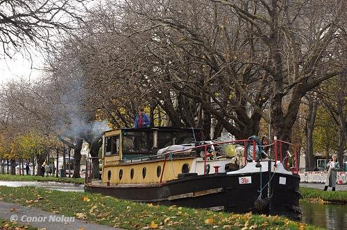
31b bei der letzten BrückendurchfahrtDie 31B in Dublin
The provisional schedule of lift dates 2016, and associated details, for Newcomen Bridge, Royal Canal, Dublin are given below. Note that mechanical repairs are required to the bridge before operation, so lifts will be subject to their completion by the dates given.
Thursday 14th Apri
11am – 1pm
Sunday 1st May
9am – 1pm
Saturday 28th May
9am – 1pm
Tuesday 14th June
11am – 1pm
Tuesday 12th July
11am – 1pm
Thursday 25th August
11am – 1pm
Monday 10th October
11am – 1pm
Arrangements have been made for Irish Rail to open the bridge on the above dates / times, if there is demand.
Waterways Ireland Eastern Regional Office (tel: +353(0)1 868 0148 or dublincanals@waterwaysireland.org) require 2 weeks’ notice from boaters for use of these lifts; should there not be demand (min 2 boats) for a particular date, Irish Rail will be notified by WI that this lift is cancelled.
A maximum number of boats passing will be implemented to keep to the times given above for the planned lifts (16 for the Sat / Sun lifts & 8 for the weekday lifts)
On day of lift, boaters and passengers must follow guidance from Waterways Ireland staff about sequence of passage under bridge & through Lock 1, and must remain within signed and designated areas.
Waterways Ireland has received a report that the Green marker stationed adjacent to Iskeraulin Shoal , south of Quaker Island, has drifted into Elfleet Bay to the East.
Masters should navigate with due caution.
Charles Lawn, Inspector of Navigation, 29 January 2016
Waterways Ireland has been requested by An Garda to limit boat movements on the Royal and Grand Canals in the Kildare area throughout this week from 25 to 31 January, during the course of an on-going investigation, particularly from the Dublin county boundary to Sallins and Maynooth respectively on the two canals.
Waterways Ireland asks that owners and masters abide by this request, and plan boat movements accordingly.
Waterways Ireland thanks its customers for their cooperation in this matter.
Charles Lawn, Inspector of Navigation, 25 January 2016