Marine Notice, No. 69 of 2025
Shannon Navigation – Lough Derg
Issued: 8 July 2025
Gaelforce Great Lake Swim
Lough Derg – Mountshannon, Saturday, 12 July 2025
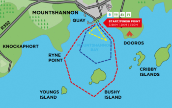
Waterways Ireland wishes to inform waterway users that the Gaelforce Great Lake Swim 2025 will take place on Lough Derg on Saturday, 12 July 2025. The event will start and finish in Mountshannon, with navigational restrictions in place on the day from 10:30 to 15:30, see below.
Navigation & Safety Advisory:
-
-
- Mountshannon Harbour and its approach routes will be closed to all vessels during this time, except those directly involved with the event.
- Swimmers and support craft will be active on the water between 10:30 & 15:30.
- Masters of vessels are asked to:
-
- Follow instructions from event marshals and safety boats.
- Keep the racecourse clear at all times.
-
- Navigation will be re-opened once all swimmers are safely out of the water.
- These temporary closures are rare and are implemented to support a unique and high-profile event that brings commercial and community benefit to the local area.
- More information available here: Gaelforce_Great_Lake_Swim_2025
-
Waterways Ireland thanks all waterway users for their cooperation and support in ensuring the safe and successful running of this event.
Peter Harty, Inspector of Navigation
Inspectorate.Athlone@waterwaysireland.org
 |
 |
 |
 |
 |
Shannon Navigation – Lough Derg, Ausgestellt: 8. Juli 2025
Gaelforce Great Lake Swim – Lough Derg – Mountshannon
Samstag, 12. Juli 2025
Waterways Ireland möchte die Nutzer der Wasserstraßen darüber informieren, dass das Gaelforce Great Lake Swim 2025 am Samstag, 12. Juli 2025, auf dem Lough Derg stattfinden wird. Die Veranstaltung beginnt und endet in Mountshannon, wobei an diesem Tag von 10:30 bis 15:30 Uhr Navigationsbeschränkungen gelten (siehe unten).
Hinweis zur Schifffahrt und Sicherheit:
- Der Hafen von Mountshannon und seine Zufahrtswege sind während dieser Zeit für alle Schiffe gesperrt, mit Ausnahme derjenigen, die direkt an der Veranstaltung beteiligt sind.
- Zwischen 10:30 und 15:30 Uhr sind Schwimmer und Begleitboote auf dem Wasser unterwegs.
- Die Kapitäne der Schiffe werden gebeten:
-
-
-
- den Anweisungen der Veranstaltungsleiter und Sicherheitsboote zu folgen.
die Rennstrecke jederzeit frei zu halten. - Die Schifffahrt wird wieder freigegeben, sobald alle Schwimmer sicher aus dem Wasser sind.
- den Anweisungen der Veranstaltungsleiter und Sicherheitsboote zu folgen.
-
-
- Diese vorübergehenden Sperrungen sind selten und werden durchgeführt, um eine einzigartige und hochkarätige Veranstaltung zu unterstützen, die der Region wirtschaftliche und gesellschaftliche Vorteile bringt.
- Weitere Informationen finden Sie hier: Gaelforce_Great_Lake_Swim_2025
Waterways Ireland dankt allen Nutzern der Wasserstraßen für ihre Zusammenarbeit und Unterstützung, um einen sicheren und erfolgreichen Ablauf dieser Veranstaltung zu gewährleisten.
