Attention !!! The maps shown on this website are for informational purposes only. They are not suitable for navigation. The map provided by the rental company must be strictly adhered to.
Waterways Ireland wishes to advise all Masters of vessels and water users that Inland Fisheries Ireland will be conducting a fish stock survey on Lough Boderg and Lough Bofin.
The survey will commence on Monday 02 September 2019 for three days.
IFI will set a maximum of 29 nets. All nets will be clearly marked by orange buoys marked IFI Survey and all will be set on the bed of the lake. The nets will avoid the main navigation channels and any heavily trafficked areas.
Masters of vessels and all water users should proceed with additional caution when operating on Lough Boderg and Lough Bofin during the period 2nd – 5th September 2019.
Waterways Ireland thanks all vessel owners and operators for their co-operation in relation to this matter.
P Harkin, Inspector of Navigation, 20 August 2019
Lough Boderg und Lough Bofin IFI Fischbestandsaufnahme Waterways Ireland möchte alle Kapitäne von Schiffen und Wassernutzern darauf hinweisen, dass Inland Fisheries Ireland eine Bestandsaufnahme über Lough Boderg und Lough Bofin durchführen wird. Die Umfrage beginnt am Montag, den 02. September 2019 für drei Tage. IFI wird maximal 29 Netze setzen. Alle Netze werden deutlich durch orangefarbene Bojen mit der Aufschrift IFI Survey gekennzeichnet und alle werden auf dem Grund des Sees aufgestellt. Die Netze vermeiden die wichtigsten Navigationskanäle und stark frequentierten Bereiche. Schiffsführer und alle Wasserbenutzer sollten beim Betrieb auf Lough Boderg und Lough Bofin im Zeitraum vom 2. bis 5. September 2019 mit zusätzlicher Vorsicht vorgehen. Waterways Ireland dankt allen Schiffseignern und Betreibern für ihre Zusammenarbeit in dieser Angelegenheit.
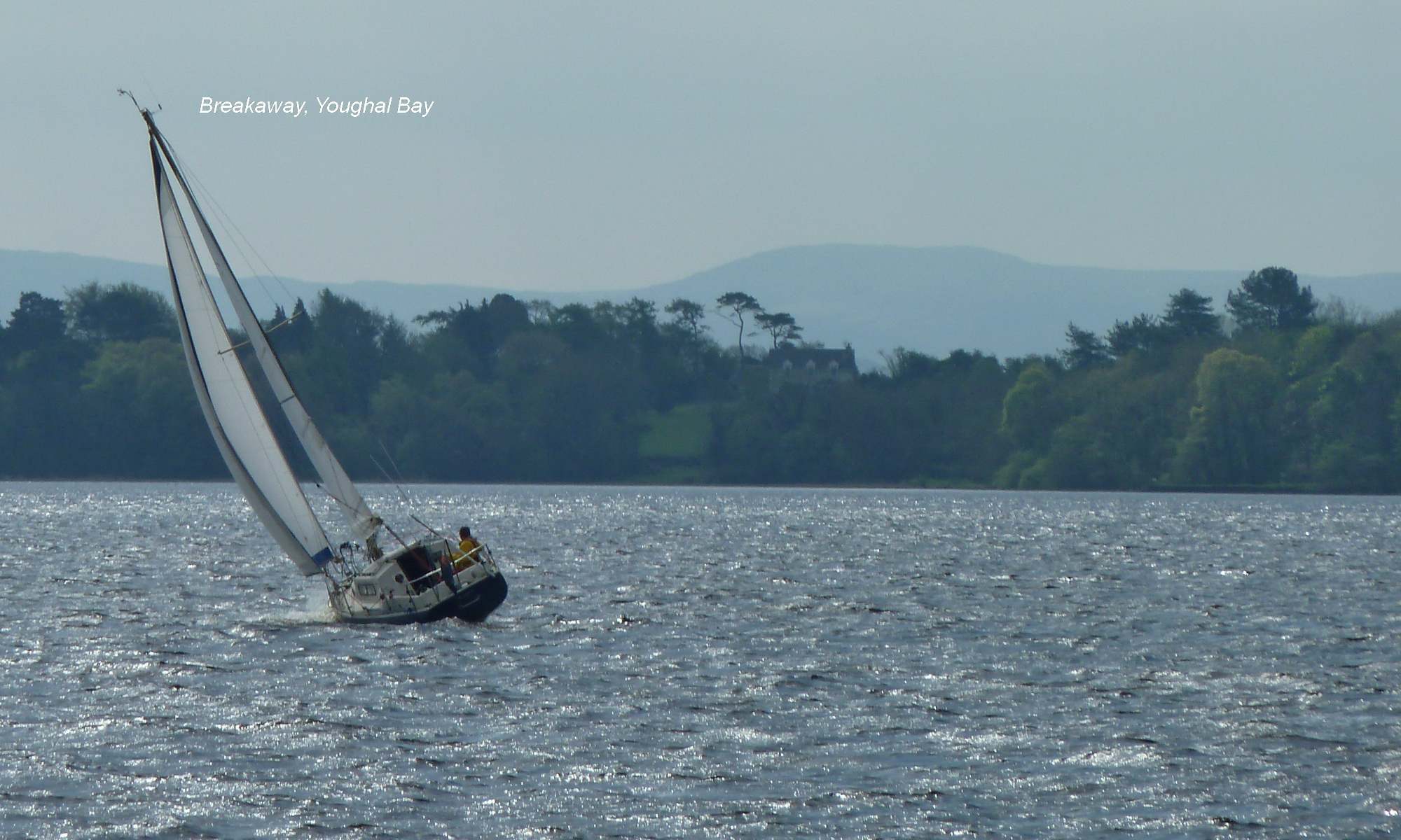
Summer 2019 on Lough Derg (Guest Writer) Views of a local boat family on Lough Derg
We spent most of the summer this year on Lough Derg. This is the largest lake on the Shannon Navigation, and we were a little apprehensive that we were going to find ourselves trapped in various ports because of high winds. As it turned out there were very few times when the weather stopped us from going out on the lake. That’s probably because we picked up a few tips from some locals. By the way, the locals on Lough Derg call themselves “Dergies”.
The first tip I was given was to download some weather apps onto my phone. I found myself using three apps in particular. XCWeather is good and easy to read. Mainly I wanted to know about wind speeds and wind direction and XCWeather provided that on an hour by hour basis. I’d have to say that Windguru was equally as good although not as easy to read. The third weather app I used is Met Eireann app. There’s a lot in this one and it’s worth spending time learning how to use their rainfall forecaster as well as rea-time rain charts. By using these we knew in advance what the wind was going to do. So we were able to move to the lee side of the lake before the wind came up and we could plan our passage wisely with good information to hand.
Another tip I got was to take a zig zag course to avoid having waved hit you side on. It does make for a longer passage, but it also makes for a much more comfortable one.
There is no doubt that this lake is stunningly beautiful as well as varied. It has wide open expanses of water as well as quiet little bays and a few tributary rivers that you can explore. At the bottom of the lake is the town of Killaloe. The trip from Parkers point to Killaloe is particularly picturesque and should be done on a bright sunny day if you get the chance.
Of course, we were busy recording lots of video while we were on the lake. Some of them we have already put up on our site and the rest will go up over the coming weeks. I think it’s fair to say that this has been a good boating season. Generally, the weather has been quite mild.
I’ll let you in on a little secret here. A way to get lots more good weather here in Ireland! Just lower the bar for what you consider to be good weather. I say that if it’s 10c or above and it’s not raining well that qualifies as good weather. So now I get lots more good weather than I used to.
Fair winds & happy boating
Harry
Video Boating in Ireland – a Trip to Killaloe
Video Boating in Ireland – Out of Killaloe
Ansichten einer einheimischen Bootsfamilie on Lough Derg Wir verbrachten den größten Teil des Sommers dieses Jahr auf dem Lough Derg. Dies ist der größte See auf der Shannon-Navigation, und wir waren ein wenig besorgt, dass wir wegen der starken Winde in verschiedenen Häfen gefangen sein würden. Wie sich herausstellte, gab es nur sehr wenige Male, als das Wetter uns davon abhielt, auf den See hinauszugehen. Das liegt wahrscheinlich daran, dass wir ein paar Tipps von einigen Einheimischen erhalten haben. Übrigens nennen sich die Einheimischen am Lough Derg „Dergies“. Der erste Tipp, den ich bekam, war, einige Wetter-Apps auf mein Handy herunterzuladen. Ich benutzte vor allem drei Apps. XCWeather ist gut und leicht zu lesen. Hauptsächlich wollte ich mehr über Windgeschwindigkeiten und Windrichtung wissen und XCWeather stellte das auf Stundenbasis zur Verfügung. Ich muss sagen, dass Windguru genauso gut, aber nicht so leicht zu lesen war. Die dritte Wetter-App, die ich benutzt habe, ist die Met Eireann App. Es gibt viel in diesem Buch und es lohnt sich, die Zeit damit zu verbringen, den Umgang mit dem Regenvorhersagegerät und den Echtzeit-Regenkarten zu erlernen. Indem wir diese nutzten, wussten wir im Voraus, was der Wind tun würde. So konnten wir uns vor dem Wind auf die Lee-Seite des Sees bewegen und unsere Passage mit guten Informationen gut planen. Ein weiterer Tipp, den ich bekam, war, einen Zickzackkurs zu nehmen (kreuzen) , um zu vermeiden, dass ich mit dem Wellenschlag auf die Seite gedrückt wurde. Es sorgt für eine längere Passage, aber auch für eine viel komfortablere. Es besteht kein Zweifel daran, dass dieser See sowohl wunderschön als auch abwechslungsreich ist. Es hat weite offene Wasserflächen sowie ruhige kleine Buchten und einige Nebenflüsse, die Sie erkunden können. Am Fuße des Sees liegt die Stadt Killaloe. Die Fahrt von Parkers Point nach Killaloe ist besonders malerisch und sollte an einem sonnigen Tag unternommen werden, wenn man die Gelegenheit dazu hat. Natürlich waren wir damit beschäftigt, viele Videos aufzunehmen, während wir auf dem See waren. Einige davon haben wir bereits auf unserer Website eingerichtet, der Rest wird in den nächsten Wochen folgen. Ich denke, dass es angemessen ist, zu sagen, dass dieses eine gute Bootfahrtsaison gewesen ist. Im Allgemeinen war das Wetter recht mild. Ich verrate dir ein kleines Geheimnis. Eine Möglichkeit, viel mehr gutes Wetter hier in Irland zu bekommen! Senken Sie einfach die Latte für das, was Sie für gutes Wetter halten. Ich sage, wenn es 10°C oder höher ist und es nicht regnet, ist das ein gutes Wetter. So bekomme ich jetzt viel mehr gutes Wetter als früher. Faire Winde & glückliche Bootstouren Harry
Waterways Ireland wishes to advise masters / owners / users of the Shannon Navigation that the ESB will be carrying out maintenance works on an Overhead Line downstream of Portumna Bridge on the Shannon Navigation on Tuesday 3rd September 2019.
The power supply for opening Portumna Bridge will be switched off between 0830hrs and 1800hrs and the bridge will be closed for the duration of the works.
The Shannon Navigation will be closed at Portumna to all vessels.
A safety boat will be on the water during the maintenance works.
Masters are requested to take heed of advice and directions from the safety boat during the maintenance works.
Waterways Ireland thanks its customers for their cooperation and apologies for any inconvenience caused.
P Harkin, Inspector of Navigation, 19 August 2019
Portumna Navigation Schließung ESB-Wartung an Freileitungen, Dienstag 03. September 2019 Waterways Ireland möchte die Kapitäne / Besitzer / Benutzer der Shannon-Navigation darauf hinweisen, dass die ESB am Dienstag, den 3. September 2019, Wartungsarbeiten an einer Oberleitung stromabwärts der Portumna Bridge auf der Shannon-Navigation durchführen wird. Die Stromversorgung zum Öffnen der Portumna-Brücke wird zwischen 0830 und 1800 Uhr abgeschaltet und die Brücke für die Dauer der Arbeiten geschlossen. Die Shannon-Navigation wird in Portumna für alle Schiffe geschlossen. Während der Wartungsarbeiten wird sich ein Sicherheitsboot auf dem Wasser befinden. Die Kapitäne werden gebeten, während der Wartungsarbeiten die Ratschläge und Anweisungen des Sicherheitsbootes zu befolgen. Waterways Ireland dankt seinen Kunden für ihre Zusammenarbeit und entschuldigt sich für die entstandenen Unannehmlichkeiten.
Waterways Ireland wishes to advise all Masters and users that in order to facilitate the annual Abbott Longford marathon road race on Sunday 25 August 2019 lifting bridge operations will be restricted accordingly.
The following air draft restrictions will apply to the lifting bridges, which will be closed during the time periods indicated below.
Royal Canal & Begnagh Bridge
The bridge will be closed from 0730hrs to 1000 hrs. The Lock keeper may be contacted on 00 353 087 9151400.
Shannon Navigation – Tarmonbarry Bridge (0845 hrs to 1200 hrs)
The air draft at Tarmonbarry at Ordinary Summer Level is 7’9″ (2.35m). The Lock keeper can be contacted during lock opening hours at 00 353 (0)43 3326117 or 087 9222020 for further information.
Shannon Navigation – Rooskey Bridge (0930 hrs to 1245 hrs)
The air draft at Roosky Bridge at Ordinary Summer Level is 10ft (3.025m). There is an air draft gauge erected at the bridge on both Upper and Lower approaches. The Lock keeper can be contacted during lock opening hours at 00 353 (0)71 96 38018 for further information.
Tarmonbarry, Rooskey & Begnagh Bridges Betriebs-beschränkungen Longford Abbott Marathon Waterways Ireland möchte alle Kapitäne und Benutzer darauf hinweisen, dass der Betrieb von Hebebrücken entsprechend eingeschränkt wird, um den jährlichen Abbott Longford Marathon-Strassenlauf am Sonntag, den 25. August 2019 zu erleichtern. Die folgenden Einschränkungen gelten für die Hubbrücken, die während der unten angegebenen Zeiträume geschlossen werden. Royal Canal – Begnagh Brücke Die Brücke wird von 0730h bis 1000h geschlossen. Der Schleusenwärter ist unter 00 353 087 9151400 zu erreichen. Shannon Navigation – Tarmonbarry Bridge (0845 Uhr) – 1200 Uhr) Die Airdraft in der Tarmonbarry auf Normal-Sommerniveau beträgt 2,35 m (7’9″). Für weitere Informationen steht der Schleusenwärter während der Öffnungszeiten der Schleuse unter 00 353 (0)43 3326117 oder 087 9222020 zur Verfügung. Shannon Navigation – Rooskey Bridge (0930 bis 1245 Uhr) Die Airdraft an der Roosky Brücke im normalen Sommerniveau beträgt 3.025 m (10 ft). An der Brücke ist sowohl im oberen als auch im unteren Bereich ein Airdraft messer angebracht. Während der Öffnungszeiten der Schleuse ist der Schleusenwärter unter 00 353 (0)71 96 38018 für weitere Informationen erreichbar.
Waterways Ireland wishes to advise it?s users that a major canoe polo event will be taking place in Mullingar Harbour from 16-18 August 2019.
Please be advised both sides of the harbour will be in use for this Canoe Polo event all weekend. Kayakers and pitch ropes will also be on the water.
Traffic will be permitted through the harbour each day 1pm-2pm and after 6pm. Passage will be facilitated by event stewards.
There will be no mooring available in the harbour area during this period. Limited moorings will be available on the Eastern side of the harbour adjacent to the bridge or alternatively at Pipers Borreen. Please liaise with event stewards.
Waterways Ireland wishes to thank its customers for their co-operation.
Patrick Harkin, Inspector of Navigation, 12 Aug 2019
Mullingar Hafen, Eingeschränkte Navigation Waterways Ireland möchte seine Benutzer darauf hinweisen, dass vom 16. bis 18. August 2019 im Mullingar Harbour ein grosses Kanupolo-Event stattfinden wird. Bitte beachten Sie, dass beide Seiten des Hafens das ganze Wochenende über für dieses Kanupolo-Event genutzt werden. Kajakfahrer und Pitchseile werden ebenfalls auf dem Wasser sein. Der Verkehr durch den Hafen wird jeden Tag von 13.00-14.00 Uhr und nach 18.00 Uhr zugelassen. Die Passage wird durch Event Stewards erleichtert. In diesem Zeitraum wird es im Hafenbereich keine Liegeplätze geben. Auf der Ostseite des Hafens neben der Brücke oder alternativ bei Pipers Borreen stehen begrenzte Liegeplätze zur Verfügung. Bitte wenden Sie sich an die Eventverantwortlichen.