MARINE NOTICE, No. 68 of 2023
SHANNON NAVIGATION
Portumna
Ballymacegan Island
Underwater Heritage Order
Designation at a “Restricted Area”
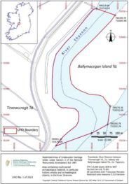
Waterways Ireland wishes to advise all masters and users of the Shannon Navigation that the Minister for Housing, Local Government and Heritage, in exercise of the powers conferred on him in section 3(1) of the National Monuments (Amendment) Act 1987 (No.17 of 1987) has ordered that the area of land covered by water (being the River Shannon) between Ballymacegan Island Townland, Co. Tipperary and Tiranascragh Townland, Co. Galway as delineated on the map below is designated under section 3(1) of the Act as a „restricted area“ within the meaning of that term under the Act.
Section 3(3) of the National Monuments (Amendment) Act 1987 states as follows:

Subject to the provisions of this section, a person shall not, in a restricted area, do any of the following, that is to say:
-
-
- tamper with, damage or remove any part of a wreck or any archaeological object,
- carry out diving, survey or salvage operations directed to the detection, location or exploration of a wreck or archaeological object or to recovering it or a part of it from, or from under, the sea bed or from land covered by water, as the case may be, or use equipment constructed or adapted for any purpose of diving, survey or salvage operations, or
- deposit, so as to fall and lie abandoned on the sea bed or land covered by water, as the case may be, anything which, if it were to fall on the site of a wreck or archaeological object (whether it so falls or not), would wholly or partly obliterate the site or obstruct access to it, or damage any part of the wreck or object.
-
Waterways Ireland thanks its customers for their co-operation in relation to this matter.
P Harkin, Inspector of Navigation, 28 July 2023
SHANNON NAVIGATION, Portumna, Ballymacegan Island
Unterwasser-Schutz-Verordnung, Ausweisung eines „Sperrgebiets“
Waterways Ireland möchte alle Kapitäne und Benutzer der Shannon Navigation davon in Kenntnis setzen, dass der Minister für Wohnungswesen, Kommunalverwaltung und Kulturerbe in Ausübung der ihm in Abschnitt 3(1) des National Monuments (Amendment) Act 1987 (No.17 of 1987) übertragenen Befugnisse angeordnet hat, dass das von Wasser bedeckte Gebiet (der Fluss Shannon) zwischen Ballymacegan Island Townland, Co. Tipperary und Tiranascragh Townland, Co. Galway, wie auf der nachstehenden Karte eingezeichnet, wird gemäß Abschnitt 3(1) des Gesetzes als „Sperrgebiet“ im Sinne dieses Begriffs des Gesetzes ausgewiesen.
Abschnitt 3(3) des National Monuments (Amendment) Act 1987 lautet wie folgt:
Vorbehaltlich der Bestimmungen dieses Abschnitts darf eine Person in einem Sperrgebiet keine der folgenden Handlungen vornehmen, d.h:
-
-
- Teile eines Wracks oder eines archäologischen Objekts zu manipulieren, zu beschädigen oder zu entfernen,
- Tauch-, Vermessungs- oder Bergungsarbeiten durchzuführen, die darauf gerichtet sind, ein Wrack oder einen archäologischen Gegenstand zu entdecken, zu lokalisieren oder zu erforschen oder es oder einen Teil davon vom Meeresboden oder von unter Wasser liegendem Land zu bergen, oder Ausrüstungen zu verwenden, die für Tauch-, Vermessungs- oder Bergungsarbeiten konstruiert oder angepasst sind, oder
- Ablagerung von Gegenständen, die, wenn sie auf ein Wrack oder ein archäologisches Objekt fallen würden (unabhängig davon, ob sie fallen oder nicht), die Fundstelle ganz oder teilweise unkenntlich machen, den Zugang zu ihr behindern oder Teile des Wracks oder des Objekts beschädigen würden, so dass sie auf den Meeresgrund oder das von Wasser bedeckte Land fallen und dort liegen bleiben.
-
Waterways Ireland dankt seinen Gästen für ihre Kooperation in dieser Angelegenheit.

