MARINE NOTICE, No. 69 of 2023

Lough Derg New Bypassbridge; © esri
Killaloe Ballina New Bypassbridge; © esri

MARINE NOTICE, No. 69 of 2023

Shannon Navigation

Killaloe and Ballina

In river works for Killaloe By-pass bridge

From 7th August 2023

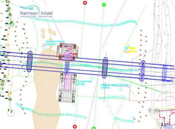
Waterways Ireland wishes to inform Masters of vessels on the Shannon Navigation that the in river works for the construction of the Killaloe By-Pass bridge are progressing as planned and will continue for several months until December 2023. The bridge is being constructed approx.
1km downstream of the current Killaloe – Ballina bridge.
A buoyed navigational channel continues to be provided for 100 metres either side of the in river works.

The following Plant & Equipment will be operating on the navigation during the in river works:

      • Jack up piling barge 22m x 17m x 2.44m
      • Stabilising Crane Barge 30m x 23m x 1.88m
      • Piling Rig 85t
      • Crawler Crane 130t
      • Tugboat / pusher boat Tiger 2
      • Dumb barge 23m x 9m
      • Landing Craft
      • Safety Boat
      • Landing pontoon + gangways

From Monday 7th August the Jack up barge will move to the West side of the navigation.
The crane barge will move to the East jetty and load out precast shells on Tuesday 8th August.
It is intended to lift precast concrete shells into position on Wed 9th, Thurs 10th and Fri 11th August 2023. This is heavy lift operations and deemed high risk work requiring calm waters.
Masters of vessels are requested to proceed at slow speed (5 knots, no wash), with additional caution in the vicinity of the works and to follow the instructions of the safety boat crew as there are hazards such as steel piles and mooring lines to navigate.
Waterways Ireland thanks its customers for their co-operation in relation to this matter.

P Harkin, Inspector of Navigation, Waterways Ireland, 28 July 2023

killaloe Bypass Shannonbridge; © esri
Killaloe New Bypass Shannonbridge; © esri

Video Boating in Ireland – a Trip to Killaloe Driftwood.TV
Killaloe New Bypass Shannonbridge; © esri

Video Boating in Ireland –Out of Killaloe Driftwood.TV
Killaloe New Bypass Shannonbridge; © esri

Shannon Navigation, Killaloe und Ballina
Bauarbeiten an der Killaloe-Umgehungsbrücke im Fluss, Ab 7. August 2023
Waterways Ireland möchte die Kapitäne von Schiffen auf der Shannon Navigation darüber informieren, dass die Arbeiten im Fluss für den Bau der Killaloe-Bypass-Brücke wie geplant voranschreiten und noch mehrere Monate bis Dezember 2023 andauern werden. Die Brücke wird ca. 1 km flussabwärts von der derzeitigen Brücke Killaloe – Ballina gebaut.
Eine betonnte Fahrrinne wird weiterhin auf einer Länge von 100 Metern beiderseits der Arbeiten im Fluss eingerichtet.
Die folgenden Anlagen und Ausrüstungen werden während der Bauarbeiten in der Fahrrinne eingesetzt:

      • Rammkahn 22m x 17m x 2,44m
      • Stabilisierungskran-Kahn 30m x 23m x 1,88m
      • Rammgerüst 85t
      • Raupenkran 130t
      • Schlepper / Schubschiff Tiger 2
      • Stummer Lastkahn 23m x 9m
      • Landungsboot
      • Sicherheitsboot
      • Anlegeponton + Laufstege

Ab Montag, dem 7. August, wird der Hubkahn auf die Westseite der Schifffahrt verlegt.
Das Kranschiff wird am Dienstag, den 8. August, an den Oststeg fahren und die Fertigteilschalen verladen.
Es ist geplant, die Fertigteilschalen am Mittwoch, den 9., Donnerstag, den 10. und Freitag, den 11. August 2023 in Position zu bringen. Es handelt sich um Schwergutarbeiten, die ein hohes Risiko darstellen und ruhige Gewässer erfordern.
Die Kapitäne von Schiffen werden gebeten, mit langsamer Geschwindigkeit (5 Knoten, keine Waschanlage) zu fahren, in der Nähe der Arbeiten zusätzliche Vorsicht walten zu lassen und den Anweisungen der Sicherheitsbootbesatzung Folge zu leisten, da Gefahren wie Stahlpfähle und Festmacherleinen zu umfahren sind.
Waterways Ireland dankt seinen Gästen für ihre Kooperation in dieser Angelegenheit.

MARINE NOTICE, No. 68 of 2023

Ballymacegan Islandk; © esri; click picture to "Arcgis Map"
Ballymacegan Islandk; © esri

MARINE NOTICE, No. 68 of 2023

SHANNON NAVIGATION

Portumna

Ballymacegan Island

Underwater Heritage Order

Designation at a “Restricted Area”

Waterways Ireland wishes to advise all masters and users of the Shannon Navigation that the Minister for Housing, Local Government and Heritage, in exercise of the powers conferred on him in section 3(1) of the National Monuments (Amendment) Act 1987 (No.17 of 1987) has ordered that the area of land covered by water (being the River Shannon) between Ballymacegan Island Townland, Co. Tipperary and Tiranascragh Townland, Co. Galway as delineated on the map below is designated under section 3(1) of the Act as a „restricted area“ within the meaning of that term under the Act.

Section 3(3) of the National Monuments (Amendment) Act 1987 states as follows:

Ballymacegan, Designation at a “Restricted Area” © UHO
Designation at a “Restricted Area” © UHO

Subject to the provisions of this section, a person shall not, in a restricted area, do any of the following, that is to say:

      1. tamper with, damage or remove any part of a wreck or any archaeological object,
      2. carry out diving, survey or salvage operations directed to the detection, location or exploration of a wreck or archaeological object or to recovering it or a part of it from, or from under, the sea bed or from land covered by water, as the case may be, or use equipment constructed or adapted for any purpose of diving, survey or salvage operations, or
      3. deposit, so as to fall and lie abandoned on the sea bed or land covered by water, as the case may be, anything which, if it were to fall on the site of a wreck or archaeological object (whether it so falls or not), would wholly or partly obliterate the site or obstruct access to it, or damage any part of the wreck or object.

Waterways Ireland thanks its customers for their co-operation in relation to this matter.

P Harkin, Inspector of Navigation, 28 July 2023

SHANNON NAVIGATION, Portumna, Ballymacegan Island
Unterwasser-Schutz-Verordnung, Ausweisung eines „Sperrgebiets“
Waterways Ireland möchte alle Kapitäne und Benutzer der Shannon Navigation davon in Kenntnis setzen, dass der Minister für Wohnungswesen, Kommunalverwaltung und Kulturerbe in Ausübung der ihm in Abschnitt 3(1) des National Monuments (Amendment) Act 1987 (No.17 of 1987) übertragenen Befugnisse angeordnet hat, dass das von Wasser bedeckte Gebiet (der Fluss Shannon) zwischen Ballymacegan Island Townland, Co. Tipperary und Tiranascragh Townland, Co. Galway, wie auf der nachstehenden Karte eingezeichnet, wird gemäß Abschnitt 3(1) des Gesetzes als „Sperrgebiet“ im Sinne dieses Begriffs des Gesetzes ausgewiesen.
Abschnitt 3(3) des National Monuments (Amendment) Act 1987 lautet wie folgt:
Vorbehaltlich der Bestimmungen dieses Abschnitts darf eine Person in einem Sperrgebiet keine der folgenden Handlungen vornehmen, d.h:

      1. Teile eines Wracks oder eines archäologischen Objekts zu manipulieren, zu beschädigen oder zu entfernen,
      2. Tauch-, Vermessungs- oder Bergungsarbeiten durchzuführen, die darauf gerichtet sind, ein Wrack oder einen archäologischen Gegenstand zu entdecken, zu lokalisieren oder zu erforschen oder es oder einen Teil davon vom Meeresboden oder von unter Wasser liegendem Land zu bergen, oder Ausrüstungen zu verwenden, die für Tauch-, Vermessungs- oder Bergungsarbeiten konstruiert oder angepasst sind, oder
      3. Ablagerung von Gegenständen, die, wenn sie auf ein Wrack oder ein archäologisches Objekt fallen würden (unabhängig davon, ob sie fallen oder nicht), die Fundstelle ganz oder teilweise unkenntlich machen, den Zugang zu ihr behindern oder Teile des Wracks oder des Objekts beschädigen würden, so dass sie auf den Meeresgrund oder das von Wasser bedeckte Land fallen und dort liegen bleiben.

Waterways Ireland dankt seinen Gästen für ihre Kooperation in dieser Angelegenheit.