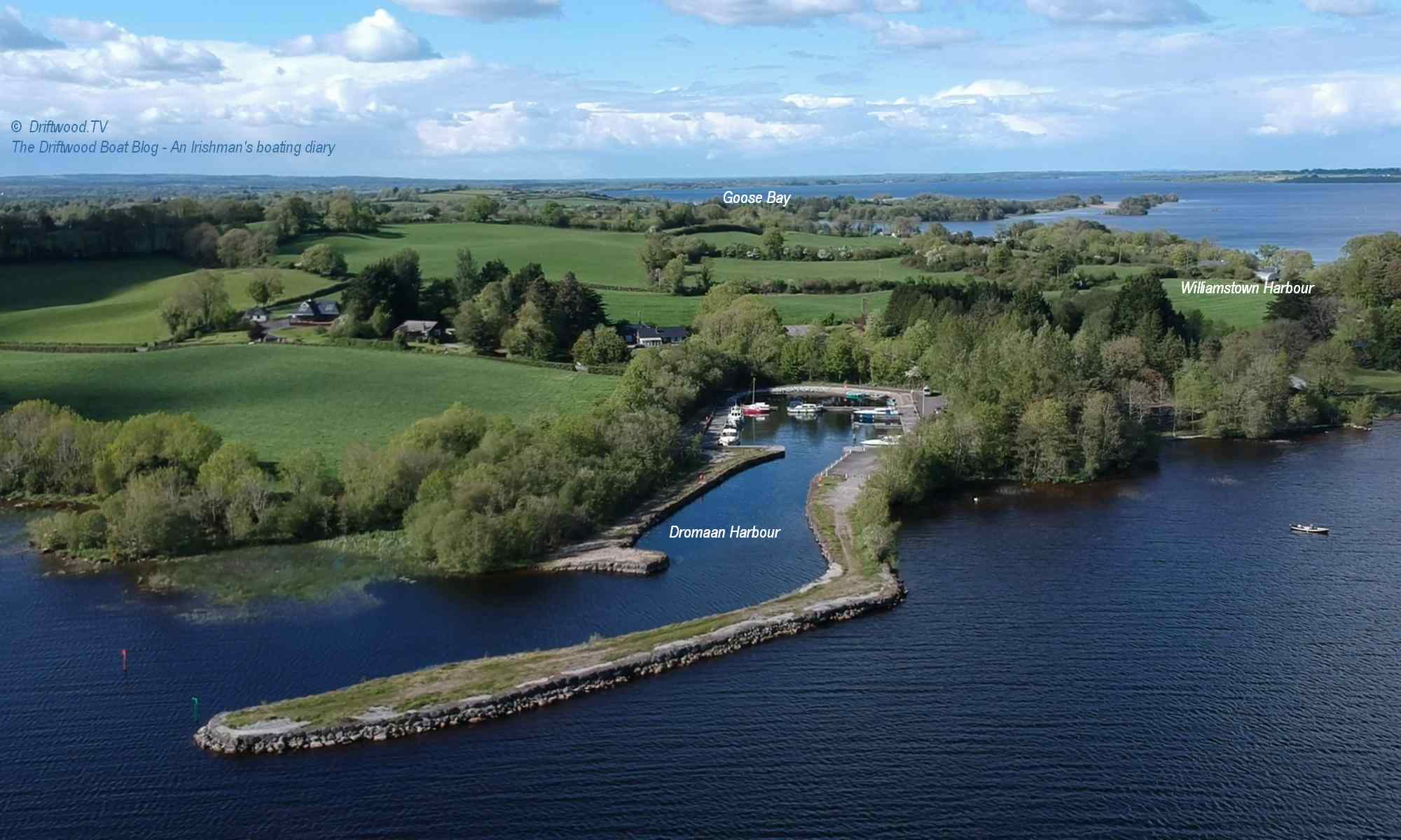
Attention !!! The maps shown on this website are for informational purposes only. They are not suitable for navigation. The map provided by the rental company must be strictly adhered to.
Waterways Ireland wishes to advise that the schedule of bridge lift dates 2017
for Newcomen Bridge, Royal Canal, Dublin are as follows:
Thursday 4th April
11am – 1pm
Sunday 30th April
9am – 1pm
Saturday 27th May
9am – 1pm
Tuesday 20th June
11am – 1pm
Tuesday 18th July
11am – 1pm
Tuesday 29th August
11am – 1pm
Thursday 12th October
11am – 1pm
NOTES:
Arrangements have been made for Irish Rail to open the bridge on the above dates / times, if there is demand.
Waterways Ireland Eastern Regional Office (tel: +353(0)1 868 0148 or dublincanals@waterwaysireland.org) require 2 weeks’ notice from boaters for use of these lifts; should there not be demand (min 2 boats) for a particular date, Irish Rail will be notified by WI that this lift is cancelled.
A maximum number of boats passing will be implemented to keep to the times given above for the planned lifts (16 for the Sat / Sun lifts & 8 for the weekday lifts). Priority will be given on a first come first served basis.
On day of lift, boaters and passengers must follow guidance from Waterways Ireland staff about sequence of passage under bridge & through Lock 1, and must remain within signed and designated areas.
Marine Notices Nos. 161 and 165 /2016 refer. Waterways Ireland wishes to advise that the Royal Canal towpath west of Maynooth from Bond Bridge to Jacksons Bridge (approx. 1.7km), will continue to be closed until March 2017 to undertake further cycle / pedestrian upgrade works along this route.
Waterways Ireland thanks its customers for their cooperation in the matter.
Charles Lawn, Inspector of Navigation, 30 Jan 2017
Waterways Ireland wishes to advise all waterway users that work to upgrade the decking on the floating moorings at Mountshannon will commence on 30 Jan and finish in or about the 10 Mar 2017.
These moorings will be a construction site for this period, masters/owners with vessels presently berthed there are requested to move their vessels to alternative moorings before the 30 Jan. The public are also requested not to enter upon the site and to be aware of warning notices in place.
Waterways Ireland thanks its customers for their cooperation in the matter.
Charles Lawn, Inspector of Navigation, 20 Jan 2017
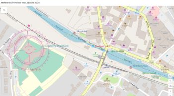
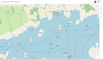
„Waterways Ireland“ hat interaktive Online Karten der irischen Wasserwege für Bootsurlauber zur Verfügung stehen.
Die Nutzer können im Bereich (oben rechts) zwischen 7 verschiedenen Grundkarten wählen. Also für Jeden was ihm am besten gefällt.
Folgende Kartentypen stehen zur Auswahl: Imagery, Imagery with Labels, National Geographic, Oceans, Open Street Map, Terrain with Labels und Topographic.
„Waterways Ireland“ has interactive online maps of Irish waterways available for boating tourism. Users can choose between 7 different basic maps in the area (top right). So for everyone he likes best. The following card types are available: Imagery, Imagery with Labels, National Geographic, Oceans, Open Street Map, Terrain with Labels and Topographic.
Die Legende auf der Karte beinhaltet Symbole für:
Information, Warning, Aid to Navigation (ATON), Air Draft Gauge, Air Draft with Red ATON, End of Navigation, Green ATON, Green ATON Large Buoy, Red ATON, Red ATON Large Buoy, Co-located Green/Red ATON, White Pillar, Marina, Mooring Places, Lock’s, Service Facilities, Pump Outs, Slipway, Waiting Jetty, Bridge, Buoys – Firing Range, Overhead Wires, Navigation Channel, Weir, Sluice Gates, Canoe Steps, Curragour Falls, Area outside marked navigation usw.
The legend on the map contains icons for: Information, Warning, Aid to Navigation (ATON), Air Draft Gauge, Air Draft with Red ATON, End of Navigation, Green ATON, Green ATON Large Buoy, Red ATON, Red ATON Large Buoy, Co-located Green/Red ATON, White Pillar, Marina, Mooring Places, Lock’s, Service Facilities, Pump Outs, Slipway, Waiting Jetty, Bridge, Buoys – Firing Range, Overhead Wires, Navigation Channel, Weir, Sluice Gates, Canoe Steps, Curragour Falls, Area outside marked navigation usw.
„Area outside marked navigation“ und „Aid to Navigation (ATON)“ die finde ich persönlich sehr gut, da die Originaldaten für die Karten auf den Vermessungen der Mitarbeiter von WI und den Bojen Setzern beruhen. Die Karten basieren auf dem „ArcGiswebappviewer“ und können auf einem Datenserver nach Feststellung einer Abweichung sofort geändert werden.
Die Zonen der „Shallow Water Areas“ Flachwasserbereiche sind hervorragend markiert.
„I personally find „Area outside marked navigation“ and „Aid to Navigation (ATON)“ very good, since the original data for the maps are based on the measurements of WI staff and the buoys setter. The maps are based on the „ArcGiswebappviewer“ and can be changed immediately after a deviation is detected on a data server. The zones of the „Shallow Water Areas“ shallow water areas are excellently marked.
Die Layer Liste beinhaltet die Operationalen Layer, die wenn man nicht alle haben will nach Bedarf durch entfernen des Hakens vor dem Layer abschalten kann aus der Karte.
The layer list contains the operational layers, which can be disabled if you don’t want to have them all by removing the check mark in front of the layer from the map.
Die Informationen die Waterways Ireland in die Symbole eingetragen hat sind aktuell und werden laufend entsprechen der Situationen geändert oder korrigiert. Achtung es sind öfter zwei Seiten, der kleine weiss Pfeile in der oberen Leiste zeigt zum umblättern.
The information that Waterways Ireland has entered in the icons is up to date and is subject to change or correction on an ongoing basis. Attention there are more often two sides, the small white arrows in the upper bar shows to turn over.
Zur besseren Ansicht des Post habe ich als Kartentyp OpenstreetMap gewählt. Serhr gut passen die Layer auch in die Imagery Ansicht auf das Luftbild schaut. Die Luftbilder sind immer aktuell.
Danke an Waterways Ireland und ArcGis die diese „Interaktive Online Charts von Waterways Ireland“ zur Nutzung zu Verfügung stellen. Als Navigations-grundlage auf den Wasserwegen gilt jedoch immer die Karte vom Vermieter.
Also mein persönliches Urteil:
Eine rundum gelungene Interaktive Karte die auf dem Handy und/oder Tablet mit der entsprechenden „prepaid flat für 31 Tage“ zur Info über die Navigation der Irischen Wasserwage sehr gut ausreichen sollte.
For a better view of the post I chose OpenstreetMap as the map type. Serhr well fit the layers also in the imagery view on the aerial view. The aerial photos are always up to date.Thanks to Waterways Ireland and ArcGis for making these „Interactive Online Charts of Waterways Ireland“ available. As navigation basis on the waterways is always the map of the landlord.
So my personal judgment: An all around successful interactive map on the mobile phone and/or tablet with the appropriate „prepaid flat for 31 days“ for information about the navigation of the Irish spirit level should be sufficient very well.