MARINE NOTICE, No.86 of 2015
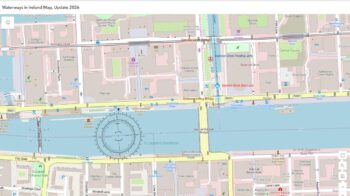
ROYAL CANAL
Spencer Dock Sea Lock, Dublin
Waterways Ireland wishes to advise masters and owners of vessels that Spencer Dock Sea Lock, Royal Canal, Dublin, is closed until further notice due to unforeseen repair requirements at one of the lock gates. Upcoming Newcomen Bridge Lifts are also cancelled until these works can be completed.
Waterways Ireland wishes to apologise to its customers for any inconvenience caused, and will issue update notice when further information is available.
Charles Lawn, Inspector of Navigation, 24 Jun 2015.